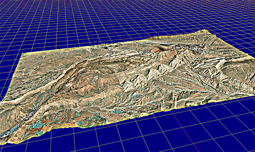
Anticlinal structure topography near Sarchahan, Iran
I learned about the current social conditions of Iran by reading the April issue of Geography magazine, "Iranian Couple."
Although unrelated to this article, I enjoyed creating a 3D model of the terrain with exposed anticlinal structures using the DEM-Net Elevation API.
雑誌地理4月号「イラン人のカップル」を読んで、当世イラン社会世相について学習しました。
この記事とは無関係ですが、背斜構造がむき出しとなった地形3DモデルをDEM-Net Elevation APIで作成して楽しみました。
1 イランのサルチャハン付近背斜構造地形
イランのサルチャハン付近背斜構造地形Anticlinal structure topography near Sarchahan, Iran
Vertical ratio: ×1
Attributions
Generator: DEM Net Elevation API - https://elevationapi.com
Mesh reduction: geometry3Sharp (GradientSpace, Ryan Schmidt) BSL 1.0 License - https://github.com/gradientspace/geometry3Sharp/blob/master/LICENSE
Digital Elevation Model: AW3D30 OpenTopography - https://opentopography.org/
Imagery: Esri World Imagery - https://services.arcgisonline.com/ArcGIS/rest/services/World_Imagery/MapServer
3Dモデルの動画
3Dモデルの画像
2 メモ
雑誌地理4月号高安克己著「イラン人のカップル」を読んで、当世イラン社会結婚事情の世相について学習しました。
この記事とは無関係ですが、Google earthを見ていると、背斜構造がむき出しとなった地形が目にとまり、自分には草食恐竜の背中の剣のような姿で珍しいので、3DモデルをDEM-Net Elevation APIで作成して楽しみました。
地形形状が尖っていて特徴的であるので、垂直比率に下駄をはかせて誇張するのは止めて、Vertical ratio: ×1としました。

0 件のコメント:
コメントを投稿