Playing with the interference color elevation map creation tool provided by Map Art Labo (Director Koji Yamada)
I played with the interference color elevation map creation tool provided free of charge by the Map Art Labo (Director Koji Yamada). I created images that processed the interference color elevation map with various filters and pasted it as textures of the terrain 3D model.
With this tool, anyone can easily create an interference color elevation map on the Geographical Survey Institute map. The interference color elevation map is an excellent tool for visualizing the detailed appearance of terrain.
地図アート研究所(所長 やまだこーじ)が無償提供する干渉色標高図作成ツールで遊びました。干渉色標高図を各種フィルターで処理した画像をつくり、地形3Dモデルのテクスチャとしてはりつけました。
このツールでは地理院地図で干渉色標高図をだれでも気軽に作成できます。干渉色標高図は地形の精細な様子を可視化することができる秀逸なツールです。
1 干渉色標高図をテクスチャとした千葉市花見川区柏井付近の地形3Dモデル 6種
干渉色標高図をテクスチャとした千葉市花見川区柏井付近の地形3Dモデル 6種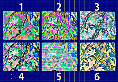
1 干渉色標高図 原図
2 干渉色標高図 くっきりバージョン(Photoshopハイパスフィルター)
3 干渉色標高図 輪郭検出バージョン(Photoshop輪郭検出フィルター)
4 干渉色標高図 水彩画風バージョン(Photoshop水彩画フィルター)
5 干渉色標高図 パッチワークバージョン(Photoshopパッチワークフィルター)
6 干渉色標高図 創作バージョン(Photoshopニューラルフィルター→スタイルの適用→アーティストスタイル→北斎)
干渉色標高図は地図アート研究所(所長 やまだこーじ)の干渉色標高図作成ツールで作成。

https://ymd5022002.github.io/map-art-jp/
地形3Dモデルは地理院地図の3Dモデル機能で作成。
Terrain 3D models near Kashiwai, Hanamigawa Ward, Chiba City, with interferometric color elevation maps as textures, 6 types
1 Interference color elevation map Original drawing
2 Interference color elevation map Clear version (Photoshop high-pass filter)
3 Interference color elevation map Contour detection version (Photoshop contour detection filter)
4 Interference color elevation map Watercolor style version (Photoshop watercolor filter)
5 Interference color elevation map Patchwork version (Photoshop patchwork filter)
6 Interference color elevation map Creative version (Photoshop neural filter → apply style → artist style → Hokusai)
The interference color elevation map was created with the interference color elevation map creation tool of Map Art Labo (Director Koji Yamada).
https://ymd5022002.github.io/map-art-en/
The terrain 3D model is created with the 3D model function of the Geographical Survey Institute map.
e.png)
3Dモデルの画像
3Dモデルの動画
2 感想
干渉色標高図作成ツールでは、色周期や階調数等を変更することで、対象とする地形の拡がりやスケールあるいは自分の問題意識に合わせた地形表現精細性を実現できます。
干渉色標高図作成ツールで作成した画像を地形3Dモデルに貼り付けると地形成り立ちや土地の歴史を知るための有用な資料とすることができます。
干渉色標高図作成ツールで作成した画像を画像ソフトの各種フィルターで処理することによって、地図アートをより深く楽しむことができます。
干渉色標高図作成ツールを公開したやまだこーじさんに感謝します。
0 件のコメント:
コメントを投稿